


A tornado-spawning thunderstorm raced across Milam County Saturday with two confirmed twisters, the most serious making a direct hit on San Gabriel.
Homes and two churches were damaged and some vacant commercial buildings were leveled in the community, one of Milam County’s oldest settlements, when an EF-0 twister touched down at 2:23 p.m.
Rockdale received mostly marble sized hail just after 7 p.m. with a few golf ball sized stones mixed in.
There were also some scattered reports of funnel cloud sightings in the city but police termed those mostly “cloud rotations” and there were no reports of tornadoes on the ground.
SAN GABRIEL—That wasn’t the case about a dozen miles to the northwest.
Videos posted by the public in the early afternoon showed a wall cloud north of Thorndale and appeared to indicate a rain-wrapped wedge tornado.
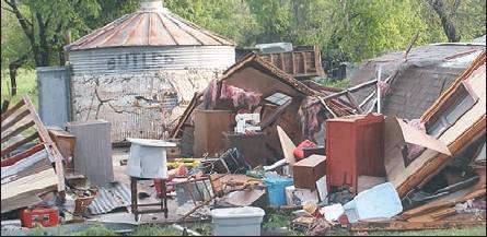
National Weather Service radar confirmed the classic “hook” shape of a twister and later determined the tornado, with winds between 65 and 85 miles per hour, was on the ground for about two minutes with a path of damage 150 yards wide and traveling a third of a mile.
Debris from demolished buildings was flung across FM 420 into the yards of homes and San Gabriel Christian Church.
The church sustained extensive roof and ceiling damage, allowing water to pour into the sanctuary of the 95-year-old building.
(The current sanctuary was constructed in 1924. The church itself dates from the 1840s—believed to be the oldest in Milam County—and has had several sanctuaries).
“Nobody was killed,” evangelist Billy Bob Cox said. “There was lots of property damage, but you can replace property.”
Cox said the congregation will have services this Sunday in an adjacent building.
Nearby San Gabriel Baptist Church was also damaged, according to congregation members who said the sanctuary sustained broken widows and there was considerable damage to the adjacent church parsonage.
San Gabriel Baptist also plans to have services this Sunday.
LANDMARK—Amazingly, the twister spared San Gabriel’s closed but iconic Stigall Store, a landmark for many decades, although debris was deposited almost on its front porch which was a “howdy neighbor” place for San Gabriel area residents during most of the 20th Century.
The current Stigall store was built in 1950 but the business dates to 1936, according to family members Zane and Eunice Stigall who live a short distance down FM 486.
“We didn’t see the tornado,” Mrs. Stigall told The Reporter. “But there was this constant rumbling.”
A number of structures in the vicinity of the store sustained damage including a former blacksmith shop across the street.
The Stigalls said downtown residents J. C. and Carolyn Payne escaped injury and their home was spared but other buildings on the property were heavily damaged.
“Some of the improvements made to the old school building were also damaged,” Mrs. Stigall said.
PATH—The storm also left multiple trees and limbs down before continuing its northeastward march across Milam County.
Sheriff Chris White said it appeared the same cell which hit San Gabriel might have produced a total of four twisters that touched down in the county.
White said the cell was active in Milam County from San Gabriel all the way into the Clarkson area of FM 1444 and FM 979 in Milam’s northeastern corner.
“After San Gabriel it appeared a tornado touched down off CR 212 around the Bud Adams Ranch,” he said.
Cameron storm spotters then observed a twister touch down north of that city in the rural area between FM 2269 and US 77, according to the sheriff’s office.
“In Milam County it (a tornado) was last seen between FM 979 and FM 2269,” he said.
There was also a report from the public of a tree blown down on some vehicles in the Marlow community, east of Cameron.
According to the National Weather Service, the San Gabriel Tornado—now its official NWS name—and one other tornado were the only ones in Milam County it could confirm.
That second Milam tornado, also an EF-0, touched down at 3:13 p.m. five miles northeast of Cameron with virtually no damage.
The tornado-producing cell then moved into Falls County with the NWS confirming another EF-0 touchdown at 3:38 p.m. two miles northwest of Calvert
HAIL—In Rockdale, during Saturday afternoon, according to Police Lt. Stephen Goodrich there were several reports of “funnel clouds” in various area of town, but police said no reports of twisters touching down reached them.
“We think those reports were probably cloud rotations,” he said.
Rotating clouds can be forerunners of tornadic activity.
Rockdale VFD storm spotters were activated at 3:40 p.m. and reported rotating clouds, and possible funnels at the FM 487-FM 1712 intersection and south of Phillips & Luckey Funeral Home off US 79.
Bur Rockdale residents couldn’t breathe easy until much later in the evening
Just after 7 p.m. the Weather Service issued a severe thunderstorm warning specifically for the Rock-dale area noting that a thunderstorm with “possible 60 mile-per-hour winds and large hail was headed from the southwest directly toward the city.”
The warning estimated the storm would hit Rock-dale by 7:30 p.m.
It arrived early, about 7:15, with a peppering of hail. Most of town observed marble-sized stones with a few as large as golf ball-sized mixed in, much of it around the downtown area.
The hailstorm in Rock-dale lasted about 5-7 minutes then moved northeast.
Police said only minor damages were reported including “dings” in vehicles.
The other part of the weekend weather arrived overnight Sunday and lasted into Tuesday.
While Rockdale received “only” 3.6 inches of rainfall, much more precipitation was recorded to the west in the drainage area for Brushy Creek and the San Gabriel River.
Those waterways, and their tributaries, flooded in the usual places, notably FM 908 and FM 486.
- Log in or Subscribe to post comments.